
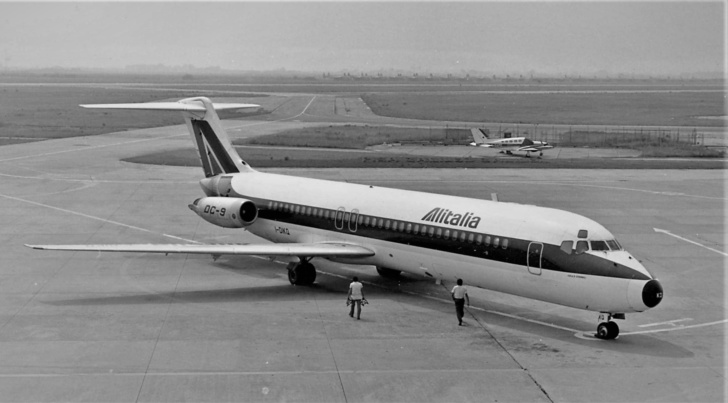
23 December 1978 - Alitalia 4128
At about 00.39 a.m. local time DC-9-32 I-DIKQ (named "Isola di Stromboli"), flight number AZA 4128, flying an extra-flight for the Christmas season from Rome Fiumicino to Palermo, crashed in the sea shortly before landing on runway 21 at Punta Raisi airport.
The aircraft was performing a VOR/DME approach to runway 21. The approach procedure dictated to establish on the 217 radial inbound of Raisi VOR/DME (identification PRS) at "Guffy" point, located 16.5 NM north-east of the VOR at 4000 ft on local QNH, then descend in order to cross the 6 DME fix at 1500 ft, the 4 DME fix at 900 ft, the 3 DME fix at 700 ft. The latter fix is also the Missed Approach Point, where, should the runway not be in sight, the crew should initiate a go-around, turning right on a 332 heading, climb to 3000 ft and wait for ATC instructions.
The final part of the approach (about two miles) is to be flown visually, the crew having to turn left to line up for runway 21, which had a magnetic heading of 206. The aircraft stopped descent at about 150 ft above the sea, as if the pilot was trying to locate the final approach area, thinking to be very close to the runway (this feeling was enhanced by the light geometry around the airport). For about nine seconds the aircraft flew almost level with the sea at 150 knots, then the wind helped to loose the final feet and the right wing impacted water. Twenty-one survivors were saved by nearby fishing boats.
At that time, Palermo airport was equipped with a primary radar Plessey ACR430, with an operative range of no more than 15 miles, usable on the North and West quadrants only due to high terrain to the East and South, and with no MTI (Moving Target Indicator) able to suppress the fixed returns, with the consequence that the inner three miles are almost blind spots to the controller. Having no secondary radar capability, the equipment is not able to give transponder answers to the controller (no identification codes and no altitude reporting), any aircraft appearing just as small unlabeled target on the screen. Reported weather at time of crash was: wind from South, variable between South and South-West, up to more than 30 knots, visibility more than 10 kilometers, scattered cumulus clouds to the West with distant showers.
Piloting the aircraft was the first officer (seven years as F/E, just three months as pilot, with 173 hours on the DC-9). The captain was a senior pilot, with great experience on the Caravelles, but just 418 hours on the DC-9.
Transcript of the Cockpit Voice Recorder (CVR)
Legenda:
APP: Palermo Procedural Approach Control
CAPT: Captain
PIL: Co-Pilot
Stw: steward
RDR: Palermo Radar Monitor
C.RAD: radio transmission by the Captain
[...]: phrases included in square brackets are integration for better clarity.
| 0:34:00 | PIL | Let's say we're leaving Guffy and four thousand. [position about 17.5 NM from PRS, altitude about 4100 ft, slightly east of the 217 radial] |
| C.RAD | Alitalia four one two eight leaving Guffy and four thousand. | |
| APP | Roger, leaving Guffy and four thousand at three-five. Report...twelve miles out. | |
| C.RAD | Twelve miles out. | |
| 0:35:15 | APP | For further, contact Radar 118.6 |
| C.RAD | One-eighteen-six. | |
| C.RAD | Radar, four-one-two-eight, good evening | |
| RDR | 4128, Radar, good evening, go ahead. | |
| C.RAD | We're leaving three thousand now and we're thirteen and half miles from Rais [PRS VOR/DME] | |
| RDR | Roger. Proceed as cleared by the Approach. Report ten miles from PRS for identification. Radar monitor service, VOR/DME two approach, runway in use 21. | |
| C.RAD | Runway 21. VOR/DME two. We'll call you at ten miles. | |
| PIL | Uh, if it's a run...we could also make a straight... | |
| Stw | Nooo.... | |
| PIL | Ah... | |
| CAPT | Mmmh...uh...Straight, there it is. Straighter than this...we're going straight to the runway. We have it slightly displaced... | |
| Stw | Yeah, I've briefly got it. | |
| CAPT | Me too, but it appears then disappers... | |
| Stw | ...then desappears and we get fucked ! | |
| PIL | Ten miles now. | |
| 0:37:00 | C.RAD | Ten miles, 4128. |
| RDR | Identified. Continue [approach]. Slightly to the right, to the right of the 217 [radial]. Report runway in sight. | |
| C.RAD. | We'll call you with the runway in sight. (Sound of radio altimeter tone, preselected) [Aircraft is passing 2000 ft radio, about 10.5 NM out, almost perfectly aligned with the 217 radial, slightly below theoretical descent path] | |
| PIL | I see the runway. | |
| Stw | It could be that one... | |
| CAPT | No, it's better to... | |
| PIL | Radio altimeter...our minima here are seven hundred. | |
| PIL | He told us we're to the right... | |
| CAPT | Slightly to the right. | |
| PIL | I'd say we're to the left. | |
| Stw | To left for me also. | |
| CAPT | Uh... | |
| 0:37:30 | PIL | The runway, that's it just ahead of us. So we were slightly to the right and not to the left. [according to radar recordings, distance is now 7.5 NM from PRS and the aircraft is diverging from the radial, being slightly to the east, that is to say right o |
| RDR | Seven miles. Aligned now. Continue and report. | |
| C.RAD. | We'll report. | |
| CAPT | Would we put something ? | |
| PIL | Fifteen ! [flaps are lowered to 15 ] | |
| PIL | Those were other lights. | |
| Stw | Maybe I was fooled by that one... | |
| 00: 38: 00 | PIL | Gear. [landing gear is extended. The aircrafts is at about 6 DME, approaching 700 ft when altitude should be 1500 ft, east of the 217 radial] |
| (sound of radio altimeter tone, 700 ft preselected) | ||
| RDR | 4128, now you're going to the left of radial. Going left of radial, about...one mile. [this information is correct regarding to the aircraft] | |
| C.RAD. | We're slightly left of radial. Which is our position at the moment ? | |
| RDR | Your position five miles. Five miles from PRS. | |
| CAPT | You got this one. But the runway is that one ! | |
| Stw | Uh. | |
| PIL | So he gave us wrong indications. | |
| CAPT | Yes. | |
| RDR | 4128, Radar. [The pilot initiates a mild right turn while continuing descent) | |
| C.RAD. | Go ahead. | |
| RDR | Four miles, still left of two-one seven. | |
| 0:38:40 | (sound of radio altimeter tone, 200 ft, automatic) | |
| CAPT | Wait a minute... | |
| PIL | So he gave us wrong indications... [Descent is stopped] | |
| CAPT | Let's call Radar... | |
| PIL | We thought we were to the left... (noise of crash. End of recording) |
Search the database
